The following excerpts on the drought situation in California come from a recent article by Daniel Swain from WeatherWest.com posted March 8, 2015.
by Daniel Swain on March 8, 2015
Recent Weather Summary
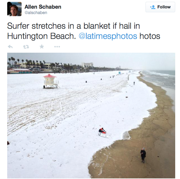
Surfer stretches in a blanket if hail in Huntington Beach. https://twitter.com/alschaben
Conditions across the state of California have varied wildly in recent weeks. While temperatures have in general been far above average–and precipitation well below what would be typical for late winter–a handful of localized but rather remarkable weather events have taken place. An accumulating blanket of small hail blanketed the shoreline at Huntington Beach, and a similar hailstorm in the suburbs of San Jose turned the green hills white with ice.
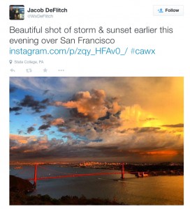
An isolated, intense, and truly spectacular severe thunderstorm rolled through South San Francisco at sunset–likely becoming one of the most widely photographed Bay Area weather events in recent years. At least one weak tornado danced across the San Joaquin Valley, and snow squalls brought weekend traffic to a standstill on Interstate 80 in the Sierra Nevada.
 California’s record-warmest winter

Yet, despite all of this wild weather, the real headline in California continues to be the exceptionally warm conditions that have persisted now for well over a year. December-February 2014-2015 was officially California’s warmest winter on record by a wide margin. February 2015 was California’s singularly warmest February on record. All of this, of course, falls on the heels of the 2014 calendar year–which was California’s warmest calendar year (and 12-month period) on record. While I realize this is all starting to sound like a broken record, that’s precisely why it bears repeating: California (and most of its geographic subregions) have been breaking high temperature records almost continuously for most of the past two years.
Even in an era of long-term global (and regional) warming, recent temperature trends in California have been extraordinary. I’ll have a more detailed post in the near future on the role of these extremely warm temperatures in worsening California’s ongoing extreme drought (and an increasing the risk of future droughts), but for now I’ll leave it at this: spring has already sprung in California, and winter never really showed up in the first place.
Ridiculously Resilient Ridge, Redux
What is the proximal cause of these extremely warm winter temperatures in California? Well, ocean temperatures remain far above normal across a vast portion of the North Pacific, and have in fact been at or near record high levels near the California coast for many months. In addition, the Ridiculously Resilient Ridge, Redux (I offer: the Quadruple-R) has redirected the Pacific storm track to the north of California for much of the past winter, much like the Triple-R before it. Poleward flow on the western flank of the persistent ridge has largely prevented cold, Arctic airmasses from reaching the state this winter–meaning that subfreezing temperatures barely occurred at all even in the colder parts of the Central Valley and that the average elevation of the freezing level in California’s mountain regions has been thousands of feet above what has historically been observed. This record-shattering warmth has been accompanied by generally below-average precipitation, which has been particularly pronounced in the central and southern Sierra Nevada. Further, the precipitation that has fallen in California this winter came in short but intense bursts–and has come interspersed between record dry spells. This combination of record warmth and notable dryness has culminated in a statewide snowpack which has now reached or even exceeded all-time record low levels.
Is there any relief on the horizon?
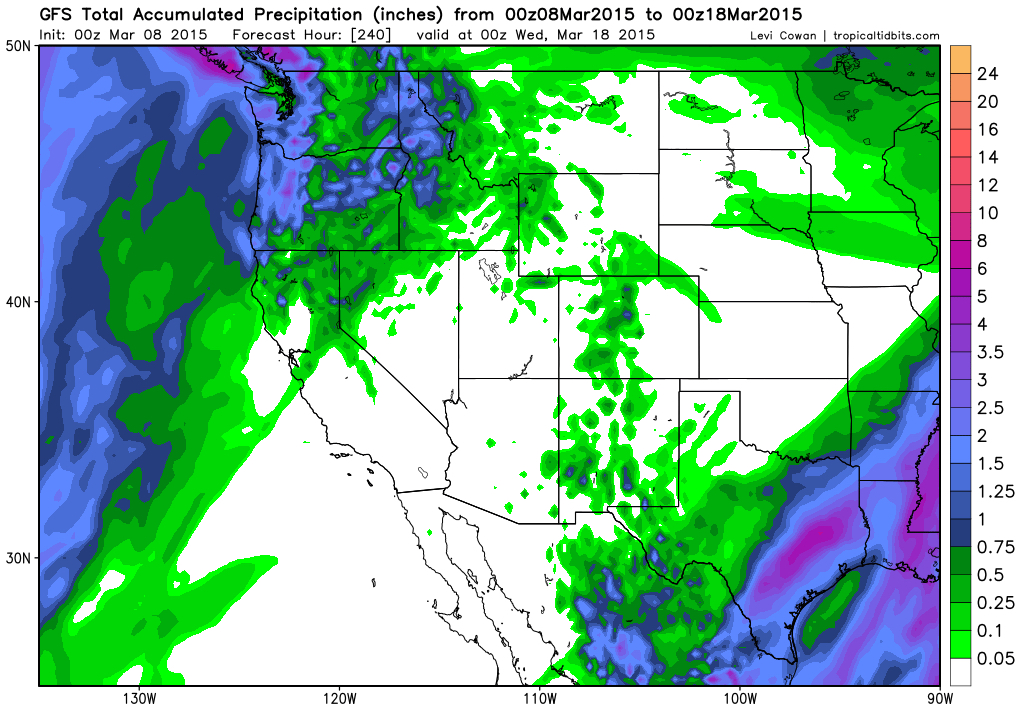
The latest GFS model forecasts bring only light precipitation to Northern California over the next 10 days. (NCEP via Levi Cowan)
Over the past few winters, the operational numerical weather models have repeatedly suggested that the unusually persistent ridge pattern over the far northeastern Pacific and West Coast of North America would give way to a more progressive, more active, stormier regime. In most instances, these early model forecasts have ultimately turned out to be wrong. Many meteorologists will attest to the tendency for operational weather models to underestimate the tenacity and resilience of so-called “blocking” high pressure systems. Given the anomalous persistence of the North Pacific ridging in recent winters, then, it’s not entirely surprising that these forecast failures have occurred (and have been decidedly prominent, given the closely-followed nature of weather forecasts calling for rain in an era of extreme drought).
Unfortunately, it appears that a similar situation has recently unfolded. Despite modest expectations a week or so ago that the first half of March might offer some hope for a colder, wetter pattern across at least the northern half of California, very warm and dry conditions have once again returned to the entire state.
There are currently some indications, once again, of the potential for a shift toward wetter conditions during the second half of March. The Madden-Julian Oscillation (MJO) is currently entering a very active phase (perhaps, according some some model forecast, even an extraordinarily active phase), which in a typical year might portend an upcoming active spell in California weather. Pacific Ocean teleconnections have been been behaving strangely these past few winters, however, so it’s not clear that this enhanced activity in the tropical West Pacific will actually translate to substantial California rain and snow.
Any such trend would, of course, be welcome news–though, as many observers have already pointed out–even such a development would likely be too little, too late from the broader perspective of the California drought. Current model solutions would fall well short of the Miracle March that many had hoped for. Periodic light rainfall is still likely across the northern parts of the state over the next two weeks, but it’s not clear at the moment whether we can expect much more than that in the near future. Given the big uptick in MJO activity, however, this is something worth keeping an eye on regarding the potential for a late-season surprise.
As I mentioned earlier in this post, I’ll be writing another extensive California climate update in the near future–exploring the latest scientific research regarding the ongoing California drought, its causes and effects, and the role of climate change in influencing the overall risk of drought in the Golden State. Stay tuned!
© 2015 WEATHER WEST
California’s drought condition and its impact on the California Almond crop is an important topic for our readers. Blue Diamond would like to thank Mr. Swain for allowing us to post excerpts of his articles on our website. To view the article in its entirety click here.